Just a quick note to let everyone know that we are doing great. We are getting acquainted at Dash Point State Park (located on Puget Sound)just south of Seattle. We'll be volunteering here until the end of September before heading off to the RV-Dreams rally in Kerrville, TX. www.rv-dreams.com
We've actually had a very good spring - still don't have the house ready to sell - but in this market that's probably just as well since we're not interested in taking a loss on it at this time. Our neighbors are doing a wonderful job taking care of the house and we really don't have many expenses with it.
We left Rochester on June 2 and arrived here on Tuesday, June 23. I'll post more this weekend with pictures of our grandsons in Colorado and granddaughters here in Seattle.
More later.......
Showing posts with label WA. Show all posts
Showing posts with label WA. Show all posts
Friday, July 03, 2009

Sunday, September 07, 2008
Catching up and Sadness
I sincerely apologize to everyone who keeps checking the blog to see where we are and what we are doing. We are just fine. In excellent health and just enjoying the freedom of this great lifestyle. But,,,,,, you knew there was a "but"
When I last posted, Stephanie and Erin had left Seattle and Lucy and her parents were in Florida; and we were expecting to leave Seattle around the 27th or 28th of August. The O'Byrne's arrived back in Seattle on Sunday, August 24th (Gretchen's birthday) and we had decided that we would leave on Tuesday or Wednesday, staying just long enough with Lucy to reacquaint with her, but not so long as to get back in a routine. Leaving a 2-year-old can be difficult for all concerned.
So we were making sure the webcams worked and talking about leaving when we received a call from Dan's older brother on Monday, August 25th telling us that their nephew, Scott Brogdon, Dave's forty-one year old son, was missing. Dave is Dan's younger brother. Scott had talked with some family members about ending his life. When we learned on Monday that Scott's body had been found in the Illinois River, Dan decided to fly back to Illinois to be with his brother and family. We were able to get a flight leaving on Tuesday through St. Louis and into Springfield where our wonderful neighbors picked him up at 9:55pm.
Scott ended his life by walking into the Illinois River, probably on Saturday, when he last spoke to his family. He had a long history of problems with alcohol and apparently just was not able to cope with his life as he saw it. He leaves behind a 20 year old son from a previous marriage and a current wife and her children, plus his parents, a brother and two half-sisters, and aunts, uncles and cousins. He will certainly be missed. We continue to keep his family in our prayers.
Sooo, Dan returned to Seattle on Saturday, August 30th. I spent the time while he was gone just being with Gretchen and her family. We didn't do a lot, but just hung out together.
We left Seattle on Labor Day for the southeastern part of Washington and spent several days near Pasco, WA at Hood Park, a Corps of Engineer park, near the confluence of the Yakima, Snake and Columbia Rivers. This park is one of the most beautiful parks we've been in. Since southeastern Washington doesn't get much rain, irrigation is everywhere. So the parks are just beautiful. There is a lot of space between the sites at Hood River with many large trees. We did not have satellite TV, but I was able to get on the Internet with my aircard. But I just couldn't get up the energy to bring the blog up to date. We really just chilled out and enjoyed the scenery. Went for several drives and visited Sacajawea State Park where Lewis and Clark camped and otherwise just generally hung out.
We had been pretty busy since we left home on June 2nd with a wedding, an RV rally, visiting with family in Denver and Carbondale, Co, having Erin with us all summer and spending a month at Lucy's house, plus the sadness of Scott's passing.
We then spent the last few days at Three Islands Crossing State Park near Glenns Ferry, ID. This was the site of the last and one of the worst crossings of the Snake River for the pioneers heading to Oregon. Another beautiful park with lots of space between sites. I know, I sound like I don't like neighbors, but that's not true. We both enjoy visiting with fellow RVers and go out of our way to meet people, but we have lived in a subdivision for many years and really enjoy looking at the scenery and not the side of an RV parked next to us. So, we really like COE, national forests and state parks.
We're moving to Massacre Rock State Park, close to American Falls, ID tomorrow for a few days. Plan to visit the replica of Fort Hall at Pocatello, ID. Fort Hall was one of the last opportunities for the pioneers to restock supplies. And there are some scenic drives in the area. We have really enjoyed following parts of the Mormom Trail and Oregon Trail. And we've also crossed part of the Lewis and Clark Trail. And we are really enjoying our mode of transportation as compared to those early settlers. :)
I'll post some pictures of the contrast between the farm land and mountains in this area. This part of Idaho gets very little rain and relies entirely on irrigation from the Snake river. The main crops are sugar beets, potatoes, hay and straw. The green of the irrigated fields next to the dry, sagebrush, tan/brown mountains is quite a contrast. There are huge stacks of BIG bales of straw in the fields. And since the rainfall is so scarce, they are are not covered with tarps like they would be in Illinois.
We're making our way toward Carbondale, CO to visit with Elijah and Isaac and their parents again as we make our way back toward Illinois.
Really do like this slow pace and the freedom of this lifestyle.
More later.......
When I last posted, Stephanie and Erin had left Seattle and Lucy and her parents were in Florida; and we were expecting to leave Seattle around the 27th or 28th of August. The O'Byrne's arrived back in Seattle on Sunday, August 24th (Gretchen's birthday) and we had decided that we would leave on Tuesday or Wednesday, staying just long enough with Lucy to reacquaint with her, but not so long as to get back in a routine. Leaving a 2-year-old can be difficult for all concerned.
So we were making sure the webcams worked and talking about leaving when we received a call from Dan's older brother on Monday, August 25th telling us that their nephew, Scott Brogdon, Dave's forty-one year old son, was missing. Dave is Dan's younger brother. Scott had talked with some family members about ending his life. When we learned on Monday that Scott's body had been found in the Illinois River, Dan decided to fly back to Illinois to be with his brother and family. We were able to get a flight leaving on Tuesday through St. Louis and into Springfield where our wonderful neighbors picked him up at 9:55pm.
Scott ended his life by walking into the Illinois River, probably on Saturday, when he last spoke to his family. He had a long history of problems with alcohol and apparently just was not able to cope with his life as he saw it. He leaves behind a 20 year old son from a previous marriage and a current wife and her children, plus his parents, a brother and two half-sisters, and aunts, uncles and cousins. He will certainly be missed. We continue to keep his family in our prayers.
Sooo, Dan returned to Seattle on Saturday, August 30th. I spent the time while he was gone just being with Gretchen and her family. We didn't do a lot, but just hung out together.
We left Seattle on Labor Day for the southeastern part of Washington and spent several days near Pasco, WA at Hood Park, a Corps of Engineer park, near the confluence of the Yakima, Snake and Columbia Rivers. This park is one of the most beautiful parks we've been in. Since southeastern Washington doesn't get much rain, irrigation is everywhere. So the parks are just beautiful. There is a lot of space between the sites at Hood River with many large trees. We did not have satellite TV, but I was able to get on the Internet with my aircard. But I just couldn't get up the energy to bring the blog up to date. We really just chilled out and enjoyed the scenery. Went for several drives and visited Sacajawea State Park where Lewis and Clark camped and otherwise just generally hung out.
We had been pretty busy since we left home on June 2nd with a wedding, an RV rally, visiting with family in Denver and Carbondale, Co, having Erin with us all summer and spending a month at Lucy's house, plus the sadness of Scott's passing.
We then spent the last few days at Three Islands Crossing State Park near Glenns Ferry, ID. This was the site of the last and one of the worst crossings of the Snake River for the pioneers heading to Oregon. Another beautiful park with lots of space between sites. I know, I sound like I don't like neighbors, but that's not true. We both enjoy visiting with fellow RVers and go out of our way to meet people, but we have lived in a subdivision for many years and really enjoy looking at the scenery and not the side of an RV parked next to us. So, we really like COE, national forests and state parks.
We're moving to Massacre Rock State Park, close to American Falls, ID tomorrow for a few days. Plan to visit the replica of Fort Hall at Pocatello, ID. Fort Hall was one of the last opportunities for the pioneers to restock supplies. And there are some scenic drives in the area. We have really enjoyed following parts of the Mormom Trail and Oregon Trail. And we've also crossed part of the Lewis and Clark Trail. And we are really enjoying our mode of transportation as compared to those early settlers. :)
I'll post some pictures of the contrast between the farm land and mountains in this area. This part of Idaho gets very little rain and relies entirely on irrigation from the Snake river. The main crops are sugar beets, potatoes, hay and straw. The green of the irrigated fields next to the dry, sagebrush, tan/brown mountains is quite a contrast. There are huge stacks of BIG bales of straw in the fields. And since the rainfall is so scarce, they are are not covered with tarps like they would be in Illinois.
We're making our way toward Carbondale, CO to visit with Elijah and Isaac and their parents again as we make our way back toward Illinois.
Really do like this slow pace and the freedom of this lifestyle.
More later.......
Thursday, July 31, 2008
Parked at Lucy's House, Playhouse, Birthday Party
Thought you might like to see our 40' motorhome parked behind Lucy's house (and the neighbor's house).

Dan drove down the alley and parallel parked between Gretchen & Rodney's blue garage and the neighbor's brother's small travel trailer. And there is a chain link/wooden fence on the other side of the motorhome. Several times he has commented, "I don't know how I did that."

Just another view of the narrow alley and the local "campground".


We are really enjoying being right in the kids back yard. Lucy and her mom have had breakfast with us and it is so nice to be able to go back and forth between houses. Makes it a lot easier to prepare meals and share food. We've enjoyed playing table games at our house after Lucy has gone to bed (with the baby monitor on); and it's nice to have our own space to retreat to without having to drive to a campground. Plus we get to sleep in our own bed every night. :) And it feels more like family time rather than just visiting. Erin has really enjoyed playing with Lucy and is earning some babysitting money.
Grandpa has been building Lucy's playhouse, so I've included some pictures. It now has a roof. The back wall is not on yet, and the door will probably be installed tomorrow or Saturday. Grandpa has been visiting the shipyard to see a fleet of ships that came in this week; and the Blue Angels are at the airport. So for those of you who may not know, Dan has a real interest in ships and airplanes, so he gets time off for some fun.


We celebrated Lucy's second birthday yesterday. The Adams family, Frank, Maggie, Bridget, Nick and Matthew came to supper along with Ella and her mom and dad, Pauline and Bill. More pictures of the birthday girl and her friends.

Notice the "Pin the Tail on the Donkey" on the side of the playhouse for Lucy's birthday party.
Terri, the neighbor who is sharing her backyard with a motorhome, gave us some bing cherries from her tree. Erin pitted them, with the cherry pitter, and Rodney showed Lucy how to put them on her fingers. Of course she now has to put her cherries on her fingers before eating them.


We are really enjoying this time in Seattle with our family.
More later......

Dan drove down the alley and parallel parked between Gretchen & Rodney's blue garage and the neighbor's brother's small travel trailer. And there is a chain link/wooden fence on the other side of the motorhome. Several times he has commented, "I don't know how I did that."

Just another view of the narrow alley and the local "campground".


We are really enjoying being right in the kids back yard. Lucy and her mom have had breakfast with us and it is so nice to be able to go back and forth between houses. Makes it a lot easier to prepare meals and share food. We've enjoyed playing table games at our house after Lucy has gone to bed (with the baby monitor on); and it's nice to have our own space to retreat to without having to drive to a campground. Plus we get to sleep in our own bed every night. :) And it feels more like family time rather than just visiting. Erin has really enjoyed playing with Lucy and is earning some babysitting money.
Grandpa has been building Lucy's playhouse, so I've included some pictures. It now has a roof. The back wall is not on yet, and the door will probably be installed tomorrow or Saturday. Grandpa has been visiting the shipyard to see a fleet of ships that came in this week; and the Blue Angels are at the airport. So for those of you who may not know, Dan has a real interest in ships and airplanes, so he gets time off for some fun.


We celebrated Lucy's second birthday yesterday. The Adams family, Frank, Maggie, Bridget, Nick and Matthew came to supper along with Ella and her mom and dad, Pauline and Bill. More pictures of the birthday girl and her friends.

Notice the "Pin the Tail on the Donkey" on the side of the playhouse for Lucy's birthday party.
Terri, the neighbor who is sharing her backyard with a motorhome, gave us some bing cherries from her tree. Erin pitted them, with the cherry pitter, and Rodney showed Lucy how to put them on her fingers. Of course she now has to put her cherries on her fingers before eating them.


We are really enjoying this time in Seattle with our family.
More later......
Saturday, July 26, 2008
We're in Seattle :-)
Hip, Hip, Hooray!!!! We arrived at Lucy's house (our soon-to-be 2-year-old granddaughter) about 1:30 this afternoon. So glad to be here. Grandpa drove down the alley behind their house and backed the motorhome into the space behind their backyard. I'll post some pictures tomorrow to give you a sense of the space he had to work with. Gretchen & Rodney's neighbor's brother has a small trailer parked next to us, so we have our own little campground.
Walked to the park about three blocks away with Lucy and Gretchen so Lucy could play in the wading pool.
Dan and Rodney are going to an air show at King airfield on Saturday. Nothing else planned for the weekend.
Just relaxing.
More later.........
Walked to the park about three blocks away with Lucy and Gretchen so Lucy could play in the wading pool.
Dan and Rodney are going to an air show at King airfield on Saturday. Nothing else planned for the weekend.
Just relaxing.
More later.........
Friday, July 25, 2008
Trees and Water
After much debate (not really debate, more indecision), we decided to drive to the South Side of Mount St. Helens to see the old-growth forests that were not damaged by the eruption in May 1980. We drove south on I-5 to Woodland and then on Route 503, then Route 90, for thirty miles up the Lewis River Valley to Cougar, WA.
The scenery was beautiful and really different than the drive on the west side of the mountain. The trees are much larger and taller, and the undergrowth much denser. The whole area has a more mature look. There are two dams across the Lewis River which makes for two beautiful reservoirs, Yale Reservoir and Swift Reservoir. Both have day areas maintained by the state of Washington with picnic sites, boat ramps and beaches. Since both reservoirs are surrounded by mountains covered by forest, the water is VERY clear. No cultivated field run-off or pollution from chemicals.


We also visited an area called the Trail of Two Forests, which is about 10 miles from Cougar. A boardwalk path meanders through what looks like a very lush, green forest. But there is a story to this forest. The visible forest and the trail are on top of an old forest that was orverrun by lava flows from Mount St. Helens almost 2,000 years ago. Mount St. Helens is an explosive volcano and typically does not expel lava. But 2,000 years ago, lava poured down the south slope of the mountain and covered the trees. Most of the trees were felled and all were killed. The lava hardened, the trees burned away, leaving molds of them behind with the imprint of bark still showing. The current forest has grown on the thin soil on top of the hard lava flow. You can actually look down into some of the tree molds. We saw snow in the bottom of one of the molds.
After leaving the Trail of Two Forests, we drove on up the road until we reached a barricade across the road. The road is closed due to some unstable edges and some rock slides. But we did see the south side of the mountain and a little stream rippling down the mountain.
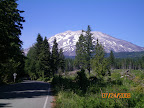
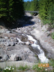
A beautiful sunny day appreciating all of Nature's glory and in awe of how powerful Nature can be.
More later....
The scenery was beautiful and really different than the drive on the west side of the mountain. The trees are much larger and taller, and the undergrowth much denser. The whole area has a more mature look. There are two dams across the Lewis River which makes for two beautiful reservoirs, Yale Reservoir and Swift Reservoir. Both have day areas maintained by the state of Washington with picnic sites, boat ramps and beaches. Since both reservoirs are surrounded by mountains covered by forest, the water is VERY clear. No cultivated field run-off or pollution from chemicals.


We also visited an area called the Trail of Two Forests, which is about 10 miles from Cougar. A boardwalk path meanders through what looks like a very lush, green forest. But there is a story to this forest. The visible forest and the trail are on top of an old forest that was orverrun by lava flows from Mount St. Helens almost 2,000 years ago. Mount St. Helens is an explosive volcano and typically does not expel lava. But 2,000 years ago, lava poured down the south slope of the mountain and covered the trees. Most of the trees were felled and all were killed. The lava hardened, the trees burned away, leaving molds of them behind with the imprint of bark still showing. The current forest has grown on the thin soil on top of the hard lava flow. You can actually look down into some of the tree molds. We saw snow in the bottom of one of the molds.
After leaving the Trail of Two Forests, we drove on up the road until we reached a barricade across the road. The road is closed due to some unstable edges and some rock slides. But we did see the south side of the mountain and a little stream rippling down the mountain.
A beautiful sunny day appreciating all of Nature's glory and in awe of how powerful Nature can be.
More later....
Wednesday, July 23, 2008
Catching UP AGAIN
Here are some links to pictures we've taken in the past 2 weeks. Just seems like I can't get "in the groove" to actually post, so thought I would play "Catch Up" with pictures and then tell you about our trip to Mt. St. Helens yesterday. So here are the links to pictures. Just click on the picture and the album will open in My Web Albums in Picasa.
The story of the Mount St. Helens eruption on May 18, 1980 is very powerful. The first earthquakes that signalled that the volcano was awakening occured in late March, 1980. As the frequency and intensity of the earthquakes increased the Forest Service and geologists were on alert and monitoring the volcano. Along with the earthquakes, which occurred about one to two miles beneath the north slope of Mount St. Helens, a large bulge was growing upward and outward on the north face of the cone. The bulge was more than a mile in diameter and pushed out 300 feet by mid-April. It was growing at a rate of five feet per day.
The Forest Service had set up a Red Zone around the mountain and had evacuated people from the area. On Saturday, May 17 some people were let back in to retrieve belongings from their homes and there were plans to let another group of people in on Sunday, May 18th. Dave Johnston, a geologist monitoring the volcano from a ridge 5.5 miles from the volcano, made an early morning radio report that the bulge continued swelling at a steady rate. An hour later Dave was dead. At 8:32 AM an earthquake of 5.1 magnitude shook Mount St. Helens and triggered a giant avalanche of the bulging north slope of the cone and slid away into Spirit Lake. The blast cloud shot out of the torn-open north face and quickly outraced the speeding avalanche. It raced north, northeast and northwest, climbing ridges and sweeping down valleys, killing everything in its path. It blew trees down like toothpicks and destroyed 230 square miles of forest. That took about 5 minutes.
The unroofed magma column jetted upward for the next nine hours into a fifteen-mile high ash cloud. More dense portions of the ash cloud near its base formed pyroclastic flows of hot rock fragments fluidized by expanding gas. These flows poured our of the horseshoe shaped crater toward Spirit Lake. Mudflows - floods of water from melting ice, the ground water soaked avalanche, and the water from Spirit Lake rushed down the stream and rivers. Homes and bridges were swept away. Much of the mud ended up in the Columbia River, clogging the navigation channel for months.
Fifty-seven people died and property damage totaled 1.5 billion dollars. One person we talked to said if it would have happened on Monday rather than Sunday, more lives would have been lost because many of the men would have been working at the logging camps.
Mother nature is doing her part to recover from this terrible event as are private and public entities. Weyerhaueser Lumber began an aggressive reforestation program and the Forest Service alone salvaged 200 million board feet of downed and standing dead trees and has replanted millions of small trees. Replanted areas are labeled with signs indicating the type of trees that were replanted and the year replanting occurred. And most amazing of all, after five years, the numbers of Roosevelt elk and black tailed deer at Mount St. Helens were back to normal.
Inside the National Monument boundaries, which include Mount St. Helens, 110,000 acres have been set aside to study Nature's process of healing itself. No replanting was done in this area, so it is still very stark with patches of renewal. Researchers from around the world are studying this area and learning about the recovery of a totally destroyed ecosystem.
Geologists continue to monitor Mount St. Helens with sophisticated equipment hoping to be better able to predict her next eruption.
The Mount St. Helens Visitor Center, at the beginning of the drive; the Forest Learning Center, and the Johnston Ridge Observatory all depict different aspects of the eruption. Each has wonderful displays and short movies which really help the visitor understand all the events that occurred on May 18, 1980.
This drive to Mount St. Helens was, for me, both very sobering and exciting. Sobering, as I saw up close what can happen in just a very few minutes when something this catastrophic takes place; but exciting to see the beautiful new trees, many of which are now 25 years old, the bright patches of color from the brightly colored flowers and the Roosevelt elk that I watched along the river from the Forest Learning Center overlook. It was also refreshing to see how the people have recovered and rebuilt as we drove along Route 504 which follows the North Fork of the Toutle River, leading to Johnston Ridge Observatory. Much of the original road was buried beneath the avalanche and mudflows of the 1980 eruption. The new road was built during 1992-1995.
We were able to see the mountain from Elk Rock lookout, but because of thick cloud cover, we could not see it from Johnston Ridge Observatory. There is a cloudy picture in the web album, and here is an "official" picture from the Mount St. Helens website.
Not sure what we doing Thursday. We may check out the south side of the mountain which was unaffected by the eruption or we may drive to the Pacific Ocean. Dan and Erin are probably getting tired of trees and more trees, so the Ocean may be a good choice. Will decide in the morning.
Happy 17th Birthday, Taylor
More later....
 |
| Redstone & Carbondale |
 |
| 2008 07 16 From Deschutes SRA, OR to Ainsworth SP, OR |
 |
| 2008 07 22 Mt St Helens drive |
The story of the Mount St. Helens eruption on May 18, 1980 is very powerful. The first earthquakes that signalled that the volcano was awakening occured in late March, 1980. As the frequency and intensity of the earthquakes increased the Forest Service and geologists were on alert and monitoring the volcano. Along with the earthquakes, which occurred about one to two miles beneath the north slope of Mount St. Helens, a large bulge was growing upward and outward on the north face of the cone. The bulge was more than a mile in diameter and pushed out 300 feet by mid-April. It was growing at a rate of five feet per day.
The Forest Service had set up a Red Zone around the mountain and had evacuated people from the area. On Saturday, May 17 some people were let back in to retrieve belongings from their homes and there were plans to let another group of people in on Sunday, May 18th. Dave Johnston, a geologist monitoring the volcano from a ridge 5.5 miles from the volcano, made an early morning radio report that the bulge continued swelling at a steady rate. An hour later Dave was dead. At 8:32 AM an earthquake of 5.1 magnitude shook Mount St. Helens and triggered a giant avalanche of the bulging north slope of the cone and slid away into Spirit Lake. The blast cloud shot out of the torn-open north face and quickly outraced the speeding avalanche. It raced north, northeast and northwest, climbing ridges and sweeping down valleys, killing everything in its path. It blew trees down like toothpicks and destroyed 230 square miles of forest. That took about 5 minutes.
The unroofed magma column jetted upward for the next nine hours into a fifteen-mile high ash cloud. More dense portions of the ash cloud near its base formed pyroclastic flows of hot rock fragments fluidized by expanding gas. These flows poured our of the horseshoe shaped crater toward Spirit Lake. Mudflows - floods of water from melting ice, the ground water soaked avalanche, and the water from Spirit Lake rushed down the stream and rivers. Homes and bridges were swept away. Much of the mud ended up in the Columbia River, clogging the navigation channel for months.
Fifty-seven people died and property damage totaled 1.5 billion dollars. One person we talked to said if it would have happened on Monday rather than Sunday, more lives would have been lost because many of the men would have been working at the logging camps.
Mother nature is doing her part to recover from this terrible event as are private and public entities. Weyerhaueser Lumber began an aggressive reforestation program and the Forest Service alone salvaged 200 million board feet of downed and standing dead trees and has replanted millions of small trees. Replanted areas are labeled with signs indicating the type of trees that were replanted and the year replanting occurred. And most amazing of all, after five years, the numbers of Roosevelt elk and black tailed deer at Mount St. Helens were back to normal.
Inside the National Monument boundaries, which include Mount St. Helens, 110,000 acres have been set aside to study Nature's process of healing itself. No replanting was done in this area, so it is still very stark with patches of renewal. Researchers from around the world are studying this area and learning about the recovery of a totally destroyed ecosystem.
Geologists continue to monitor Mount St. Helens with sophisticated equipment hoping to be better able to predict her next eruption.
The Mount St. Helens Visitor Center, at the beginning of the drive; the Forest Learning Center, and the Johnston Ridge Observatory all depict different aspects of the eruption. Each has wonderful displays and short movies which really help the visitor understand all the events that occurred on May 18, 1980.
This drive to Mount St. Helens was, for me, both very sobering and exciting. Sobering, as I saw up close what can happen in just a very few minutes when something this catastrophic takes place; but exciting to see the beautiful new trees, many of which are now 25 years old, the bright patches of color from the brightly colored flowers and the Roosevelt elk that I watched along the river from the Forest Learning Center overlook. It was also refreshing to see how the people have recovered and rebuilt as we drove along Route 504 which follows the North Fork of the Toutle River, leading to Johnston Ridge Observatory. Much of the original road was buried beneath the avalanche and mudflows of the 1980 eruption. The new road was built during 1992-1995.
We were able to see the mountain from Elk Rock lookout, but because of thick cloud cover, we could not see it from Johnston Ridge Observatory. There is a cloudy picture in the web album, and here is an "official" picture from the Mount St. Helens website.
 |
| Mount St. Helens |
Not sure what we doing Thursday. We may check out the south side of the mountain which was unaffected by the eruption or we may drive to the Pacific Ocean. Dan and Erin are probably getting tired of trees and more trees, so the Ocean may be a good choice. Will decide in the morning.
Happy 17th Birthday, Taylor
More later....
Subscribe to:
Posts (Atom)




 Posts

